Welcome
Chuckanut Mountain Trails
In the winter Chuckanut is considerably drier than other trails in Whatcom County.
The Chuckanut Mountain wildfire flames have been put out. So, what’s next?
Read more here: http://www.bellinghamherald.com/news/local/article165472517.html#storylink=cpy
8.3.2017
Chuckanut fire 50 percent under control; full containment expected by week’s end
Read more here: http://www.bellinghamherald.com/news/local/article165179027.html#storylink=cpy
8.2.2017
Hey folks,
Just a head’s up, there’s a 60 acre fire burning off of Burnout Road on Chuckanut right now.
Clayton Beach Parking lot is closed for staging the fire crews and trucks. There’s roughly 100 firefighters on the fire right now. They will be going up Fragrance Lake Road to Burnout to work on the fire.
http://komonews.com/news/local/wildfire-near-chuckanut-mountain-threatening-4-homes
While trails are still open, we’d advise staying away from Chuckanut / Larrabee State Park until further notice. It’s super hazy over there and there will be a lot of vehicle activity.
Last, it goes without saying, but with the extreme dry conditions and heat, there are NO fires allowed outdoors in Western Washington / Whatcom County right now.
Cheers,
EB
TrailChuckanut Ridge Trail (Technical)
|
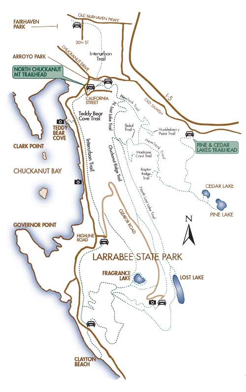
Trail Info (recommended routs)From Arroyo Park area: (take I-5 exit 250 West. Drive down Old Fairhaven Parkway to the edge of Fairhaven. Turn left on Chuckanut Drive by 12th St. Drive south and at the fork in the road either take a left on Old Samish Parkway and park at Arroyo Park (small) or take a right on Chuckanut Drive and park in the larger gravel lot (North Chuckanut Trailhead).
Ride the interurban trail South from the large gravel lot about 12.5 miles to the Fragrance Lake trailhead. Ride up Fragrance Lake road. At the top, don’t go left into Fragrance Lake but keep going straight up a on what is now a single track connector. It will climb a bit and come out on Cleator Road. Take a left down hill on Cleator Road for about a half mile. Turn right into the trial. It will climb a bit and join the middle and upper ridge trail. Turn Left (North) and ride the Middle and Lower ridge all the way back to California St. Logging roads. Keep left and ride the road back to the parking area. There are great views of Galbraith from this ride if you stop and look east from the cliff tops. |
|
Double Black Diamond
(Technical steep downhill) |
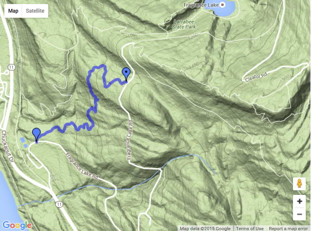
Ride up Fragrance Lake road. At the top, don’t go left into Fragrance Lake but keep going straight up a on what is now a single track connector. It will climb a bit and come out on Cleator Road.
Turn Right and ride to the top parking area. Hike a bike up the trail on the east side and then ride the trail down. At the bottom take a right and go back to the top of Fragrance Lake road. Either ride the connector up again and take the Ridge Trail down or ride the road down. This is a great shuttle trail… park at the base of Cleator road and shuttle up. |
|
Double Down
Double Down on Chuckanut may be ridden after riding Double Black Diamond or you can hike up to the trail from the Lost Lake Trail parking lot by Larrabee State Park. If you park in the lot you will need a Discover Pass. Min Elevation:232 ft Max Elevation:1,038 ft 
Giant tree on Double Down Trail
|
Double Down on Chuckanut
|